The time has come when satellite images are becoming more and more accessible to everyone through LandViewer. The following article presents a complete LandViewer review for your better understanding. This trend has been observed throughout the last decade. The development of this situation is still ongoing. There are great opportunities to use this valuable data.
And the results of its analysis in solving a wide range of problems on Earth. Right now, many industries are tapping into this rich data resource. This is for process understanding, providing great potential for breakthrough innovation. Initially, this area could seem reserved for GIS professionals, but free satellite imagery is now widely available to anyone who wants to use it.
The GIS data market is rapidly changing and attracting more players who offer customers detailed satellite images of Earth. Data, as well as tools for geospatial imaging of our planet, are becoming more complex. Nowadays, customers need not only high-quality commercial images but also radar data.
Companies in the GIS data analytics market are striving to meet these requirements. Among such companies is EOS Data Analytics, which offers different software solutions that leverage satellite imagery analytics for various industries. One of its products is a tool called LandViewer, a satellite imagery catalogue that provides search and analytics. It also provides downloads of historic and the most up-to-date satellite images.
See Also: 18 Best Websites to Watch Anime/Cartoon Online {Updated}
Table of Contents
All You Need To Know About LandViewer: LandViewer Review
Fundamentally, LandViewer is a real-time image processing and analytics service that provides:
- Fast access to petabytes of new and archived Earth imagery
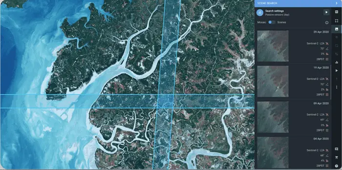
- There is a wide range of possibilities for searching geospatial images at any scale in 2 clicks by selecting the area of interest (AOI) on the map or by the location’s name.
- Real-time data analysis with the ability to upload images of any required location.
LandViewer covers a vast number of public libraries. For providing high and very high-resolution imagery (up to 0.4 m per pixel), the tool obtains images from a host of satellites, including SuperView, KOMPSAT-2, KOMPSAT-3A, KOMPSAT-3, Ziyuan-3, Gaofen 1, Gaofen 2, and TripleSat. These are satellite images from CBERS-4, Sentinel 1 and 2, MODIS / NAIP, Landsat 7 and 8, and Landsat 4 and 5 for historical photos.
Images are easy to find by specifying the area of interest using many options and uploading a file. The sensor type and timeframe are selected. Cloud cover, altitude, and AOI coverage percentages are available as filter search conditions. Plus, users can save their area of interest and subscribe to new scenes to quickly get what they need in the future. Besides, they can easily upload a processed image, a combination of bands, or a calculated index.
LandViewer immediately offers the selected image’s analytical visualization capabilities, making the service unique among many other platforms. More than 20 standard band combinations and indices are shown, including NDVI, NBR, and SAVI. Users can also create their custom index. And use clustering, time series analysis, and other features to tailor the image to their needs. LandViewer enables the download of any live satellite imagery with a wide range of bands or natural colors. It can be full or cropped in JPEG, KMZ, or GeoTIFF format—more details about high-resolution images.
Some of the most prominent options LandViewer has to offer:
The following are some of the possibilities for LandViewer reviews:
Change Over Time Observation
Having near real-time satellite images and historical data, it is much easier for users to detect and monitor changes over a certain period. Users select an area of interest, a satellite dataset, and a period. The algorithm will deliver results in a few moments, generating a Time Series graph. There is also an option of creating a time-lapse animation from a series of satellite images of Earth taken in the same AOI to see how the change happened in real-time.
Advanced Vegetation Analysis
Users looking for advanced vegetation cover analysis can use LandViewer’s spectral indexes, including NDVI, SAVI, EVI, ARVI, GCI, SIPI, and NBR. Using different indices simultaneously enables better precision and more intelligent decision-making thanks to comprehensive analytics based on various parameter measurements.
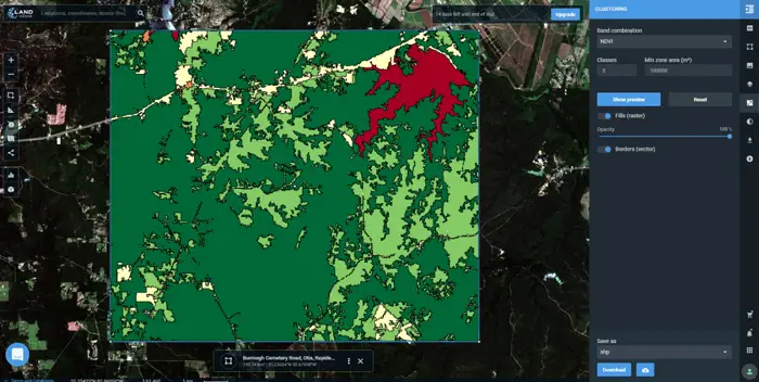
Analytics by Different Zones
The tool enables users to run data-based satellite classification of an area of up to 200 square kilometers into clusters (zones). After the user sets custom parameters (size/number of zones), the app will create a raster image of the area with color-marked zones and boundaries outlined. Such analytics can offer insights into agriculture, forestry, and other industries. For example, farmers can create NDVI value maps for specific activities management.
Imagery Exchange
LandViewer software allows users from different spheres of expertise to participate in a profitable and mutually beneficial exchange of satellite pictures. The tool enables purchasing and reselling imagery with analytics catering to various industries, like agriculture, forestry, mining, urban planning, ocean observation, and more. The already mentioned ability to make a time-lapse animation also means that you can share this short video with others via social media, post it in news articles to showcase the change occurring in a particular location, etc.
Although geographic location information is already available to most Internet users, the more convenient geodata platforms become, the more information you can obtain and analyze with their assistance. Companies that understand this trend create services for collecting, studying, visualizing, and storing satellite images. LandViewer by EOSDA offers invaluable features that you can access directly from a browser window for the user to benefit. Depending on the industry and issues that require research. For instance, using a digital satellite imagery analytics tool allows the detection of changes in the landscape. It also tracks deforestation, determines the boundaries of agricultural land, counts cars in a parking lot to predict retailers’ sales, etc.
Conclusion
So, in conclusion, La ndViewer review: LandViewer is a satellite imagery catalog where users can search, process, and download satellite pictures of Earth conveniently in one place. Catering to various industries that require satellite data, LandViewer can also be integrated into any third-party GIS software, enabling a full-circle data workflow to pull out actionable insights.